Geolocate

Fustat topographic map

Click on the map to display elevation.

About this map

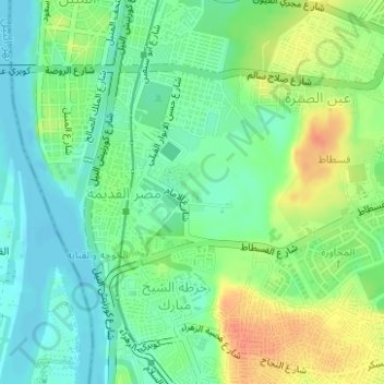
Name: Fustat topographic map, elevation, terrain.

Location: Fustat, Masr Al-Qadima, El Sheikh Mubarak, Cairo, Egypt (30.00358 31.22954 30.01115 31.24117)

Average elevation: 29 m

Minimum elevation: 12 m

Maximum elevation: 56 m

Gear up for your next adventure:

🧦Hiking Liner Socks - Thin base layer to prevent friction and blisters
💡LED Camping Lantern - Illuminate your campsite with long-lasting lanterns
🥾Light Hiking Boots - Lightweight and comfortable boots for day hikes
🧴Outdoor Sunscreen - High SPF protection for high-altitude UV exposure
🥾Hiking Leggings - Comfortable leggings for outdoor activities

As an Amazon Associate, this site earns from qualifying purchases at no extra cost to you.