
Make a donation
Gear up for your next adventure:
As an Amazon Associate, this site earns from qualifying purchases at no extra cost to you.
Khorramabad topographic map
Click on the map to display elevation.
Make a donation
Gear up for your next adventure:
As an Amazon Associate, this site earns from qualifying purchases at no extra cost to you.
Khorramabad
Khorramabad has what is classed under the Köppen climate classification as a Hot-summer Mediterranean climate (Csa) climate. Its elevation is 1147.8 above sea level. Average annual precipitation is 511.06 and its average annual temperature is 17.21 Celsius.
Make a donation
Gear up for your next adventure:
As an Amazon Associate, this site earns from qualifying purchases at no extra cost to you.
About this map
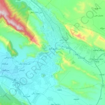
Name: Khorramabad topographic map, elevation, terrain.
Average elevation: 1,368 m
Minimum elevation: 1,126 m
Maximum elevation: 2,391 m
Make a donation
Gear up for your next adventure:
As an Amazon Associate, this site earns from qualifying purchases at no extra cost to you.
Other topographic maps
Click on a map to view its topography, its elevation and its terrain.
ایستگاه تنگ هفت
Iran > Lorestan Province > Khorramabad County > دهستان تنگ هفت
Average elevation: 1,022 m