Geolocate

Zinal topographic map

Click on the map to display elevation.

About this map

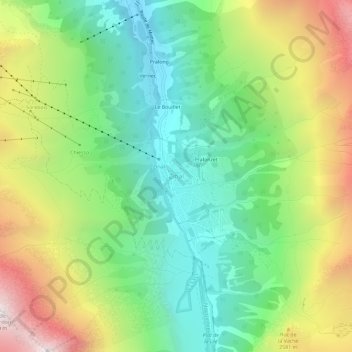
Name: Zinal topographic map, elevation, terrain.

Location: Zinal, Anniviers, Sierre, Wallis, 3961, Switzerland (46.11629 7.60680 46.15629 7.64680)

Average elevation: 2,209 m

Minimum elevation: 1,551 m

Maximum elevation: 3,293 m

Other topographic maps

Click on a map to view its topography, its elevation and its terrain.

Lac de Châteaupré

Switzerland > Wallis > Sierre > Anniviers

Average elevation: 2,646 m

Gear up for your next adventure:

💧Reusable Water Bottle - Durable water bottles for hydration on trails
🧭GPS Outdoor Watch - Smart watch for navigation and fitness tracking in nature
🩹Moleskin Blister Pads - Direct protection for painful foot pressure points
🔦LED Headtorch - Bright and durable light for night activities
🥾Trail Hiking Boots - Supportive boots for rough trails

As an Amazon Associate, this site earns from qualifying purchases at no extra cost to you.