
Thank you for supporting this site ❤️
Make a donation
Make a donation
Gear up for your next adventure:
As an Amazon Associate, this site earns from qualifying purchases at no extra cost to you.
Samilpamba topographic map
Click on the map to display elevation.
Thank you for supporting this site ❤️
Make a donation
Make a donation
Gear up for your next adventure:
As an Amazon Associate, this site earns from qualifying purchases at no extra cost to you.
About this map
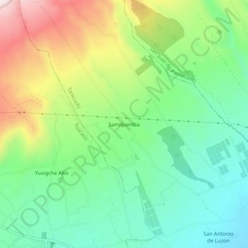
Name: Samilpamba topographic map, elevation, terrain.
Location: Samilpamba, Tanicuchí, Latacunga, Cotopaxi, 050161, Ecuador (-0.75538 -78.69462 -0.71538 -78.65462)
Average elevation: 3,281 m
Minimum elevation: 3,093 m
Maximum elevation: 3,619 m
Thank you for supporting this site ❤️
Make a donation
Make a donation
Gear up for your next adventure:
As an Amazon Associate, this site earns from qualifying purchases at no extra cost to you.