Geolocate

Rosewood topographic map

Click on the map to display elevation.

About this map

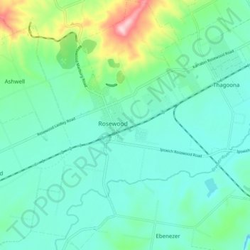
Name: Rosewood topographic map, elevation, terrain.

Location: Rosewood, Ipswich City, Queensland, 4340, Australia (-27.68084 152.56233 -27.59945 152.63625)

Average elevation: 71 m

Minimum elevation: 13 m

Maximum elevation: 287 m

Other topographic maps

Click on a map to view its topography, its elevation and its terrain.

Stanton Cross

Australia > Queensland > Ipswich City

Average elevation: 28 m

Mount Grey

Australia > Queensland > Ipswich City

Average elevation: 231 m

Spring Mountain

Australia > Queensland > Ipswich City

Average elevation: 190 m

White Rock

Australia > Queensland > Ipswich City

Average elevation: 114 m

Gear up for your next adventure:

🛌Insulated Sleeping Pad - Critical thermal barrier between you and the cold ground
Tent Footprint - Protect tent floor and increase durability
🧥Waterproof Pants - Keep dry during rainy hiking conditions
🔨Vehicle Emergency Tool - Safety tool for remote road trips to trailheads
🥾Waterproof Hiking Shoes - Durable shoes for wet and rugged trails

As an Amazon Associate, this site earns from qualifying purchases at no extra cost to you.