Geolocate

Port Ghalib topographic map

Click on the map to display elevation.

About this map

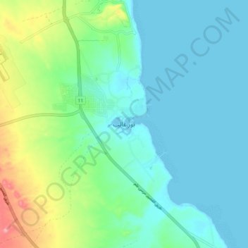
Name: Port Ghalib topographic map, elevation, terrain.

Location: Port Ghalib, Red Sea, Egypt (25.49171 34.59376 25.57171 34.67376)

Average elevation: 29 m

Minimum elevation: 0 m

Maximum elevation: 128 m

Other topographic maps

Click on a map to view its topography, its elevation and its terrain.

Gulf of Suez

Egypt > Red Sea

Average elevation: 481 m

Gulf of Suez

Egypt > Red Sea

Average elevation: 481 m

Gamsha

Egypt > Red Sea

Average elevation: 47 m

Al Hadaba

Egypt > Red Sea

Average elevation: 41 m

Al Hadaba

Egypt > Red Sea

Average elevation: 41 m

Marsa Alam City

Egypt > Red Sea

Average elevation: 19 m

Industrial Area

Egypt > Red Sea

Average elevation: 38 m

Gulf of Suez

Egypt > Red Sea

Average elevation: 481 m

Geziret Tubya

Egypt > Red Sea > Safaja

Average elevation: 0 m

Wadi Gemal

Egypt > Red Sea

Average elevation: 374 m

Safaja

Egypt > Red Sea

Average elevation: 1 m

Industrial Area

Egypt > Red Sea

Average elevation: 38 m

Al Ahia'

Egypt > Red Sea

Average elevation: 16 m

Al Qusair City

Egypt > Red Sea

Average elevation: 47 m

Gear up for your next adventure:

🥾Light Hiking Boots - Lightweight and comfortable boots for day hikes
Tent Footprint - Protect tent floor and increase durability
🛌Insulated Sleeping Pad - Critical thermal barrier between you and the cold ground
🔦LED Headtorch - Bright and durable light for night activities
🧥Softshell Jacket - Windproof and breathable jacket for hiking

As an Amazon Associate, this site earns from qualifying purchases at no extra cost to you.