Geolocate

Hagdan topographic map

Click on the map to display elevation.

About this map

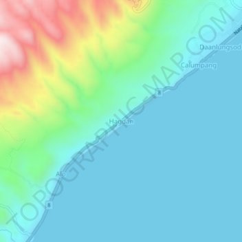
Name: Hagdan topographic map, elevation, terrain.

Location: Hagdan, Cebu, Central Visayas, Philippines (9.48031 123.38574 9.52031 123.42574)

Average elevation: 125 m

Minimum elevation: 0 m

Maximum elevation: 587 m

Gear up for your next adventure:

Lightweight Backpacking Tent - Compact tent for efficient hiking trips
🧥Fleece Jacket - Warm and lightweight jacket for layering
🧦Hiking Socks - Moisture-wicking and comfortable socks for long hikes
💡LED Camping Lantern - Illuminate your campsite with long-lasting lanterns
👟Leg Gaiters - Keep debris, mud, and snow out of your boots

As an Amazon Associate, this site earns from qualifying purchases at no extra cost to you.