
Make a donation
Gear up for your next adventure:
As an Amazon Associate, this site earns from qualifying purchases at no extra cost to you.
Nippes topographic map
Click on the map to display elevation.
Make a donation
Gear up for your next adventure:
As an Amazon Associate, this site earns from qualifying purchases at no extra cost to you.
Nippes
Im Gebiet des heutigen Kölner Stadtteils Nippes lag nachweislich bereits in der Römerzeit eine Villa. Am Rande des Nippeser Tälchens, eines heute verlandeten Altarms des Rheines (am heutigen Niehler Kirchweg), lag der alte Siedlungskern des heutigen Nippes, die Herrlichkeit Mauenheim. Die Wohnplatzbezeichnung Nippes selbst erscheint erstmals in einer Urkunde des Jahres 1549 im Zusammenhang mit einem damals bekannten Gasthaus (in Höhe der heutigen Florastraße, die damals „Kappesgasse“ hieß). Der Name Nippes (Nipp-Haus) lässt sich möglicherweise als Haus auf einer Anhöhe deuten. Im 17. Jahrhundert war die Gastronomie om Nippes berühmt-berüchtigt.
Make a donation
Gear up for your next adventure:
As an Amazon Associate, this site earns from qualifying purchases at no extra cost to you.
About this map
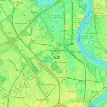
Name: Nippes topographic map, elevation, terrain.
Location: Nippes, Köln, Nordrhein-Westfalen, Deutschland (50.95374 6.89148 51.02377 6.99903)
Average elevation: 47 m
Minimum elevation: 33 m
Maximum elevation: 63 m
Make a donation
Gear up for your next adventure:
As an Amazon Associate, this site earns from qualifying purchases at no extra cost to you.
Other topographic maps
Click on a map to view its topography, its elevation and its terrain.
Make a donation
Gear up for your next adventure:
As an Amazon Associate, this site earns from qualifying purchases at no extra cost to you.