
Redfish Lake topographic map
Interactive map
Click on the map to display elevation.
About this map
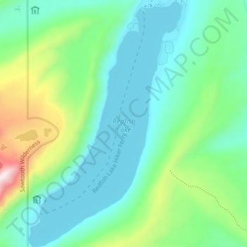
Name: Redfish Lake topographic map, elevation, terrain.
Location: Redfish Lake, Custer County, Idaho, United States (44.09323 -114.95587 44.14436 -114.91176)
Average elevation: 2,144 m
Minimum elevation: 1,989 m
Maximum elevation: 2,637 m
The surface elevation of Redfish Lake is 6,547 feet (1,996 m) above sea level. The lake is 4.5 miles (7.2 km) long and 0.72 miles (1.2 km) wide, with a maximum depth of 387 feet (118 m), and 11 miles (18 km) of shoreline. The actual trail around the lake is 17.5 miles (28 km) in length.
Other topographic maps
Click on a map to view its topography, its elevation and its terrain.
Stanley Lake
United States > Idaho > Custer County
Stanley Lake, Custer County, Idaho, United States
Average elevation: 2,075 m
Stanley
United States > Idaho > Custer County
Stanley, Custer County, Idaho, United States
Average elevation: 1,931 m
Pine Summit
United States > Idaho > Custer County
Pine Summit, Custer County, Idaho, United States
Average elevation: 2,315 m
Thousand Springs
United States > Idaho > Custer County
Thousand Springs, Custer County, Idaho, United States
Average elevation: 1,922 m
Challis
United States > Idaho > Custer County
Challis, Custer County, Idaho, United States
Average elevation: 1,626 m
Borah Peak
United States > Idaho > Custer County
Borah Peak, Custer County, Idaho, United States
Average elevation: 3,280 m
Lost River
United States > Idaho > Custer County
Lost River, Custer County, Idaho, United States
Average elevation: 2,198 m