
Make a donation
Gear up for your next adventure:
As an Amazon Associate, this site earns from qualifying purchases at no extra cost to you.
Patuhā topographic map
Click on the map to display elevation.
Make a donation
Gear up for your next adventure:
As an Amazon Associate, this site earns from qualifying purchases at no extra cost to you.
About this map
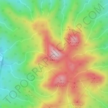
Name: Patuhā topographic map, elevation, terrain.
Location: Patuhā, New Plymouth District, Taranaki, 4314, New Zealand (-39.16136 173.96563 -39.16126 173.96573)
Average elevation: 413 m
Minimum elevation: 218 m
Maximum elevation: 648 m
Make a donation
Gear up for your next adventure:
As an Amazon Associate, this site earns from qualifying purchases at no extra cost to you.
Other topographic maps
Click on a map to view its topography, its elevation and its terrain.
Te Papa-Kura-o-Taranaki
New Zealand > Taranaki > New Plymouth District
The park is located on the west coast of the North Island and is exposed to prevailing winds from the west or northwest. Moist westerlies from the Tasman Sea create orographic precipitation when they reach Mount Taranaki and the adjacent Pouākai and Kaitake ranges. Southerly winds are also common. The…
Average elevation: 500 m