Geolocate

Soledad topographic map

Click on the map to display elevation.

About this map

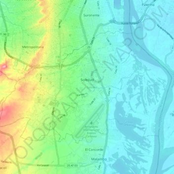
Name: Soledad topographic map, elevation, terrain.

Location: Soledad, Atlántico, RAP Caribe, Colombia (10.87513 -74.83908 10.94538 -74.72830)

Average elevation: 31 m

Minimum elevation: -1 m

Maximum elevation: 125 m

Other topographic maps

Click on a map to view its topography, its elevation and its terrain.

Barranquilla

Colombia > Atlántico > Barranquilla

Average elevation: 27 m

Puerto Colombia

Colombia > Atlántico > Puerto Colombia

Average elevation: 32 m

Puerto Colombia

Colombia > Atlántico > Puerto Colombia

Average elevation: 32 m

Malambo

Colombia > Atlántico > Malambo

Average elevation: 22 m

Gear up for your next adventure:

🔥Camping Stove - Portable stoves to cook outdoors with ease
Tent Footprint - Protect tent floor and increase durability
🔦LED Headlamp - Hands-free lighting for early morning starts or late finishes
🧢Beanie Hat - Keep your head warm in cold weather
🧤Rechargeable Heated Gloves - Extreme warmth for Canadian winter expeditions

As an Amazon Associate, this site earns from qualifying purchases at no extra cost to you.