
Thank you for supporting this site ❤️
Make a donation
Make a donation
Gear up for your next adventure:
As an Amazon Associate, this site earns from qualifying purchases at no extra cost to you.
Calachota topographic map
Click on the map to display elevation.
Thank you for supporting this site ❤️
Make a donation
Make a donation
Gear up for your next adventure:
As an Amazon Associate, this site earns from qualifying purchases at no extra cost to you.
About this map
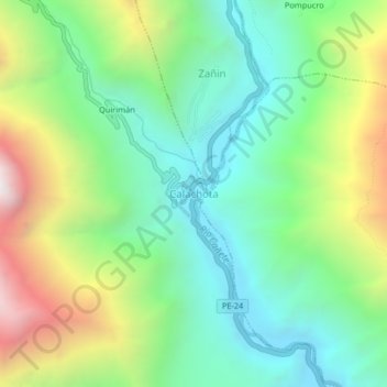
Name: Calachota topographic map, elevation, terrain.
Location: Calachota, Ayauca, Yauyos, Lima, Perú (-12.65154 -75.99926 -12.61154 -75.95926)
Average elevation: 2,197 m
Minimum elevation: 1,671 m
Maximum elevation: 3,235 m
Thank you for supporting this site ❤️
Make a donation
Make a donation
Gear up for your next adventure:
As an Amazon Associate, this site earns from qualifying purchases at no extra cost to you.