
Thank you for supporting this site ❤️
Make a donation
Make a donation
Gear up for your next adventure:
As an Amazon Associate, this site earns from qualifying purchases at no extra cost to you.
Pellegrino topographic map
Click on the map to display elevation.
Thank you for supporting this site ❤️
Make a donation
Make a donation
Gear up for your next adventure:
As an Amazon Associate, this site earns from qualifying purchases at no extra cost to you.
About this map
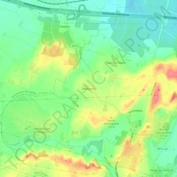
Name: Pellegrino topographic map, elevation, terrain.
Location: Pellegrino, Pozzolengo, Brescia, Lombardije, 25010, Italië (45.39631 10.59343 45.43631 10.63343)
Average elevation: 101 m
Minimum elevation: 73 m
Maximum elevation: 140 m
Thank you for supporting this site ❤️
Make a donation
Make a donation
Gear up for your next adventure:
As an Amazon Associate, this site earns from qualifying purchases at no extra cost to you.