
Make a donation
Gear up for your next adventure:
As an Amazon Associate, this site earns from qualifying purchases at no extra cost to you.
3. Watzmannkind topographic map
Click on the map to display elevation.
Make a donation
Gear up for your next adventure:
As an Amazon Associate, this site earns from qualifying purchases at no extra cost to you.
About this map
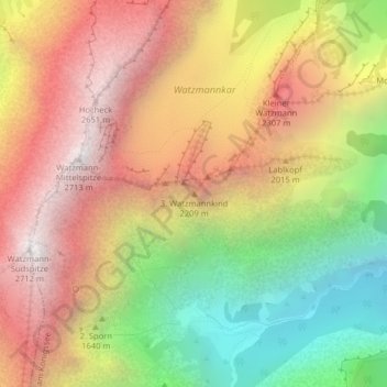
Name: 3. Watzmannkind topographic map, elevation, terrain.
Average elevation: 1,767 m
Minimum elevation: 721 m
Maximum elevation: 2,683 m
Make a donation
Gear up for your next adventure:
As an Amazon Associate, this site earns from qualifying purchases at no extra cost to you.
Other topographic maps
Click on a map to view its topography, its elevation and its terrain.
Funtensee
Deutschland > Bayern > Landkreis Berchtesgadener Land > Schönau am Königssee
Der Funtensee ist ein Karstsee im Gebirgsmassiv des Steinernen Meeres im Nationalpark Berchtesgaden und liegt auf einer Höhe von 1601 m ü. NHN. Überregionale Bekanntheit hat der See durch seine lagebedingten Kälterekorde erlangt, die jedoch für die weitere Umgebung nicht repräsentativ sind.
Average elevation: 1,813 m
Eisgraben
Deutschland > Bayern > Landkreis Berchtesgadener Land > Schönau am Königssee
Average elevation: 1,260 m