Geolocate

Payerne topographic map

Click on the map to display elevation.

About this map

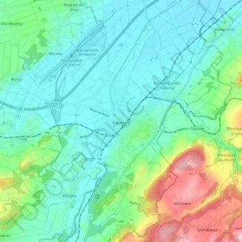
Name: Payerne topographic map, elevation, terrain.

Location: Payerne, District de la Broye-Vully, Vaud, Switzerland (46.78085 6.90488 46.86162 6.96662)

Average elevation: 495 m

Minimum elevation: 436 m

Maximum elevation: 677 m

Gear up for your next adventure:

🛏️Sleeping Bag - Warm and compact sleeping bags for outdoor camping
Lightweight Backpacking Tent - Compact tent for efficient hiking trips
💡LED Headlamp - Hands-free illumination for night hiking and camping
🎒Backpack Rain Cover - External shield to keep your entire pack dry
🥾Light Hiking Boots - Lightweight and comfortable boots for day hikes

As an Amazon Associate, this site earns from qualifying purchases at no extra cost to you.