Geolocate

Victor topographic map

Click on the map to display elevation.

About this map

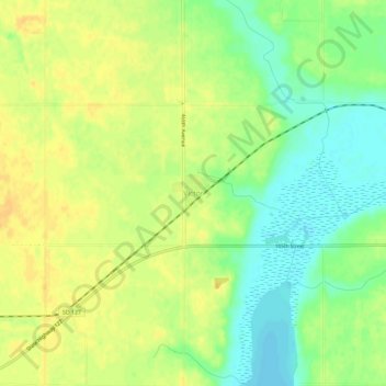
Name: Victor topographic map, elevation, terrain.

Location: Victor, Roberts County, South Dakota, United States (45.84885 -96.85286 45.88885 -96.81286)

Average elevation: 327 m

Minimum elevation: 312 m

Maximum elevation: 338 m

Other topographic maps

Click on a map to view its topography, its elevation and its terrain.

Rosholt

United States > South Dakota > Roberts County

Average elevation: 325 m

Summit

United States > South Dakota > Roberts County > Summit

Summit was laid out in 1892, and was so named on account of the town site's lofty elevation.

Average elevation: 609 m

Gear up for your next adventure:

🕶️Polarized Sunglasses - Reduces glare from snow and water at high elevations
🛏️Sleeping Bag - Warm and compact sleeping bags for outdoor camping
🛶Waterproof Dry Bags - Keep electronics and clothes dry during river crossings
💡LED Headlamp - Hands-free illumination for night hiking and camping
🧼Biodegradable Camp Soap - Environmentally friendly cleaning for gear and body

As an Amazon Associate, this site earns from qualifying purchases at no extra cost to you.