
Make a donation
Gear up for your next adventure:
As an Amazon Associate, this site earns from qualifying purchases at no extra cost to you.
Mistretta topographic map
Click on the map to display elevation.
Make a donation
Gear up for your next adventure:
As an Amazon Associate, this site earns from qualifying purchases at no extra cost to you.
About this map
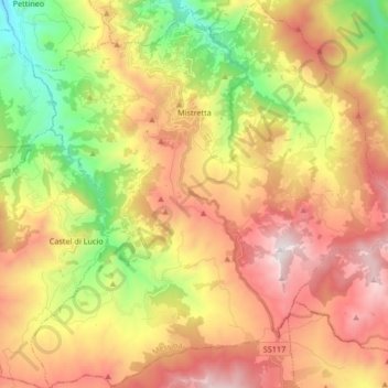
Name: Mistretta topographic map, elevation, terrain.
Location: Mistretta, Messina, Sicilië, 98073, Italië (37.83656 14.29280 37.96788 14.45717)
Average elevation: 810 m
Minimum elevation: 87 m
Maximum elevation: 1,544 m
Make a donation
Gear up for your next adventure:
As an Amazon Associate, this site earns from qualifying purchases at no extra cost to you.
Other topographic maps
Click on a map to view its topography, its elevation and its terrain.
Isola di Stromboli
Italië > Sicilië > Messina > Lipari
Bijna alle bewoners wonen aan de veilige noordoostkant van het eiland. Sommigen zijn nog visser, maar de meesten werken ten behoeve van het toerisme. De landbouw, vooral wijn- en olijfgaarden, heeft weinig betekenis meer. Er is een haven en een van de plaatsjes heeft een strand van zwart vulkaanzand. De vijf…
Average elevation: 160 m
Lipari
Bijna alle bewoners wonen aan de veilige noordoostkant van het eiland. Sommigen zijn nog visser, maar de meesten werken ten behoeve van het toerisme. De landbouw, vooral wijn- en olijfgaarden, heeft weinig betekenis meer. Er is een haven en een van de plaatsjes heeft een strand van zwart vulkaanzand. De vijf…
Average elevation: 372 m
Make a donation
Gear up for your next adventure:
As an Amazon Associate, this site earns from qualifying purchases at no extra cost to you.