
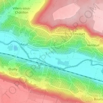
Maisons de l'Échelle topographic map
Interactive map
Click on the map to display elevation.
About this map
Name: Maisons de l'Échelle topographic map, elevation, terrain.
Average elevation: 150 m
Minimum elevation: 53 m
Maximum elevation: 263 m
Other topographic maps
Click on a map to view its topography, its elevation and its terrain.
Les Crayères
France > Grand Est > Marne > Cœur-de-la-Vallée
Les Crayères, Reuil, Cœur-de-la-Vallée, Épernay, Marne, Grand Est, France métropolitaine, 51480, France
Average elevation: 126 m
Villers-sous-Châtillon
France > Grand Est > Marne > Cœur-de-la-Vallée
Villers-sous-Châtillon, Cœur-de-la-Vallée, Épernay, Marne, Grand Est, France métropolitaine, 93000, France
Average elevation: 220 m
Reuil
France > Grand Est > Marne > Cœur-de-la-Vallée
Reuil, Cœur-de-la-Vallée, Épernay, Marne, Grand Est, France métropolitaine, 93000, France
Average elevation: 141 m