Geolocate

Midway topographic map

Click on the map to display elevation.

About this map

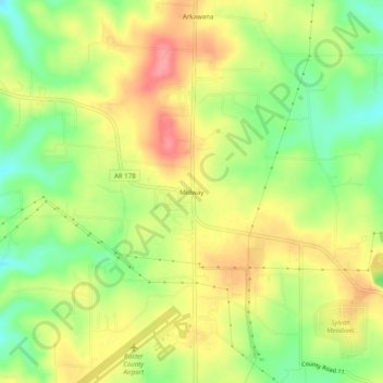
Name: Midway topographic map, elevation, terrain.

Location: Midway, Baxter County, Arkansas, 72651, United States (36.36534 -92.48183 36.40534 -92.44183)

Average elevation: 269 m

Minimum elevation: 224 m

Maximum elevation: 312 m

Other topographic maps

Click on a map to view its topography, its elevation and its terrain.

Gassville

United States > Arkansas > Baxter County

Average elevation: 200 m

Salesville

United States > Arkansas > Baxter County

Average elevation: 170 m

Big Flat

United States > Arkansas > Baxter County

Average elevation: 354 m

Norfork Lake

United States > Arkansas > Baxter County

Average elevation: 226 m

Briarcliff

United States > Arkansas > Baxter County

Average elevation: 236 m

Gear up for your next adventure:

🔨Vehicle Emergency Tool - Safety tool for remote road trips to trailheads
🥾Mountain Hiking Shoes - Shoes with superior grip for mountainous terrain
🔋Emergency Crank Radio - Weather alerts and power without needing batteries
🚲Handlebar Phone Mount - View topographic-map.com live while cycling
🧥Waterproof Hiking Jacket - Protect yourself from rain and wind while hiking

As an Amazon Associate, this site earns from qualifying purchases at no extra cost to you.