Geolocate

Nottingham topographic map

Click on the map to display elevation.

About this map

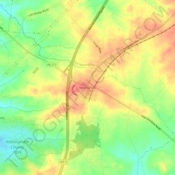
Name: Nottingham topographic map, elevation, terrain.

Location: Nottingham, West Nottingham Township, Chester County, Pennsylvania, 19362, United States (39.72844 -76.03856 39.76844 -75.99856)

Average elevation: 145 m

Minimum elevation: 108 m

Maximum elevation: 178 m

Other topographic maps

Click on a map to view its topography, its elevation and its terrain.

Gear up for your next adventure:

🪑Ultralight Camping Stool - Compact seating for rest stops during long hikes
🧭GPS Tracker - Track your location in remote areas safely
🎒Hiking Backpack - Lightweight and ergonomic backpacks for day hikes or multi-day treks
🧢Sun Hat - Wide-brim hat for sun protection
🥾Trail Hiking Boots - Supportive boots for rough trails

As an Amazon Associate, this site earns from qualifying purchases at no extra cost to you.