
Make a donation
Gear up for your next adventure:
As an Amazon Associate, this site earns from qualifying purchases at no extra cost to you.
Jungeroth topographic map
Click on the map to display elevation.
Make a donation
Gear up for your next adventure:
As an Amazon Associate, this site earns from qualifying purchases at no extra cost to you.
About this map
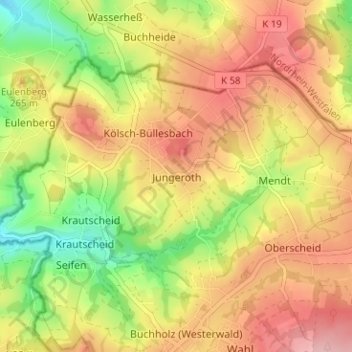
Name: Jungeroth topographic map, elevation, terrain.
Average elevation: 236 m
Minimum elevation: 155 m
Maximum elevation: 303 m
Make a donation
Gear up for your next adventure:
As an Amazon Associate, this site earns from qualifying purchases at no extra cost to you.
Other topographic maps
Click on a map to view its topography, its elevation and its terrain.
Neuwied
Deutschland > Rheinland-Pfalz > Landkreis Neuwied
Neuwied liegt am rechten Ufer des Rheins am Fuße des Westerwalds in Höhe der Mündung des Flusses Wied. Im Gegensatz zu den sonst schmalen Tälern des Mittelrheins weichen die Berghänge im Neuwieder Becken einige Kilometer zurück. Die Bundesstadt Bonn liegt rund 50 Kilometer nordwestlich von Neuwied, die…
Average elevation: 172 m
Bad Hönningen
Deutschland > Rheinland-Pfalz > Landkreis Neuwied
1204 wurde erstmals die „Pfarrei Hönningen“ genannt, die eine gemeinsame Gründung des Hochstifts Bamberg und des Trierer Simeonsstifts war. Bereits vorher, 1135, war es zwischen Bamberg und Trier zu Streitigkeiten über die Verteilung des Zehnten gekommen. Papst Hadrian IV. bestätigte 1155 dem…
Average elevation: 151 m