
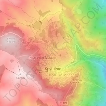
Krushevo topographic map
Interactive map
Click on the map to display elevation.
About this map
Name: Krushevo topographic map, elevation, terrain.
Average elevation: 1,219 m
Minimum elevation: 869 m
Maximum elevation: 1,411 m
Kruševo (Macedonian: Крушево [ˈkruʃɛvɔ] ; Aromanian: Crushuva) is a town in North Macedonia. In Macedonian the name means the 'place of pear trees'. It is the highest town in North Macedonia and one of the highest in the Balkans, situated at an altitude of over 1350 m (4429 feet) above sea level. The town of Kruševo is the seat of Kruševo Municipality. It is located in the western part of the country, overlooking the region of Pelagonia, 33 and 53 km from the nearby cities of Prilep and Bitola, respectively.
Other topographic maps
Click on a map to view its topography, its elevation and its terrain.
Dragosh
North Macedonia > Pelagonia Region > Dragosh
Dragosh, Municipality of Bitola, Pelagonia Region, North Macedonia
Average elevation: 808 m
Lake Prespa
North Macedonia > Pelagonia Region
Lake Prespa, Pelagonia Region, North Macedonia
Average elevation: 1,067 m