Geolocate

Jefferson topographic map

Click on the map to display elevation.

About this map

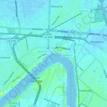
Name: Jefferson topographic map, elevation, terrain.

Location: Jefferson, Jefferson Parish, Louisiana, 70121, United States (29.94419 -90.20844 29.97413 -90.12769)

Average elevation: 3 m

Minimum elevation: -5 m

Maximum elevation: 20 m

Other topographic maps

Click on a map to view its topography, its elevation and its terrain.

Metairie

United States > Louisiana > Jefferson Parish

Average elevation: 2 m

Gretna

United States > Louisiana > Jefferson Parish > Gretna > Gretna

Gretna is located at 29°54′59″N 90°3′15″W / 29.91639°N 90.05417°W / 29.91639; -90.05417 (29.916459, -90.054260) and has an elevation of 0 feet (0 m) behind the levee along the Mississippi River.

Average elevation: 2 m

Gear up for your next adventure:

🧦Hiking Socks - Moisture-wicking and comfortable socks for long hikes
Camping Tent - Weather-resistant tents suitable for 2 to 6 people
🥾Trail Hiking Shoes - Durable shoes designed for rugged trails
🪜Heavy Duty Carabiners - Multi-use clips for securing gear to your backpack
🧢Hiking Sun Hat - Wide-brimmed protection for exposed mountain ridges

As an Amazon Associate, this site earns from qualifying purchases at no extra cost to you.