Geolocate

Elon topographic map

Click on the map to display elevation.

About this map

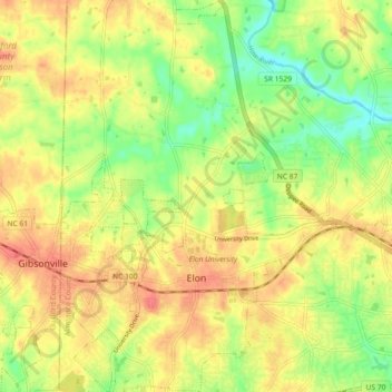
Name: Elon topographic map, elevation, terrain.

Location: Elon, Alamance County, North Carolina, United States (36.08151 -79.53514 36.15483 -79.47482)

Average elevation: 202 m

Minimum elevation: 171 m

Maximum elevation: 227 m

Other topographic maps

Click on a map to view its topography, its elevation and its terrain.

Glencoe

United States > North Carolina > Alamance County

Average elevation: 184 m

Elon

United States > North Carolina > Alamance County > Elon

Average elevation: 201 m

Gear up for your next adventure:

💡Compact LED Flashlight - Powerful and portable flashlight for outdoor use
🥾Waterproof Hiking Shoes - Durable shoes for wet and rugged trails
🔋Lithium AA Batteries - Long-lasting power that performs in extreme cold
Backpacking Tent - Lightweight tent for long-distance hiking trips
🧥Insulated Jacket - Keep warm in cold outdoor conditions

As an Amazon Associate, this site earns from qualifying purchases at no extra cost to you.