
Tressingen topographic map
Interactive map
Click on the map to display elevation.
Tressingen
Die Ortschaft liegt zehn Kilometer nordwestlich von Thionville (deutsch Diedenhofen) und sechs Kilometer südlich der Grenze zu Luxemburg auf einer Höhe zwischen 316 und 392 m über dem Meeresspiegel, die mittlere Höhe beträgt 346 m. Das Gemeindegebiet umfasst 9,36 km². Zur Gemeinde gehören die Ortsteile Bure und Ludelange.
About this map
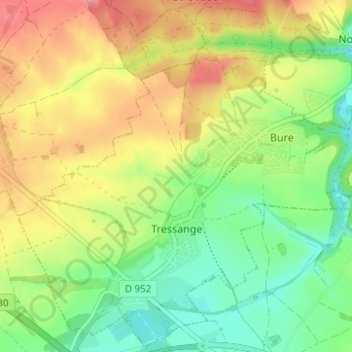
Name: Tressingen topographic map, elevation, terrain.
Average elevation: 359 m
Minimum elevation: 318 m
Maximum elevation: 408 m