
Make a donation
Gear up for your next adventure:
As an Amazon Associate, this site earns from qualifying purchases at no extra cost to you.
Elbrus District topographic map
Click on the map to display elevation.
Make a donation
Gear up for your next adventure:
As an Amazon Associate, this site earns from qualifying purchases at no extra cost to you.
About this map
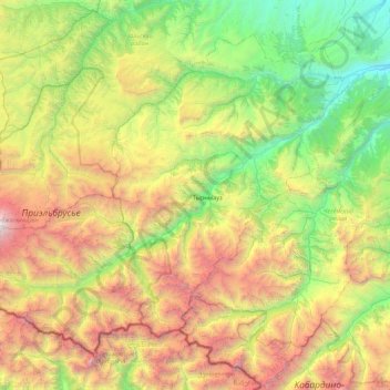
Name: Elbrus District topographic map, elevation, terrain.
Average elevation: 2,306 m
Minimum elevation: 652 m
Maximum elevation: 5,485 m
Make a donation
Gear up for your next adventure:
As an Amazon Associate, this site earns from qualifying purchases at no extra cost to you.
Other topographic maps
Click on a map to view its topography, its elevation and its terrain.
Central Caucasian Ridge
Russia > Kabardino-Balkaria > Cherek District > Verkhnyaya Balkariya
The highest and rockiest section of the range is located in its central part. Although not as high as the topmost summits of the Lateral Range to the north, the highest elevations of the Main Caucasian Range include the 5,193 meters (17,037 ft) high Shkhara, the 4,466 meters (14,652 ft) high Mount Bazardüzü…
Average elevation: 2,784 m
Shkhara
Russia > Kabardino-Balkaria > Cherek District > Verkhnyaya Balkariya
Average elevation: 4,355 m
Mount Elbrus (East Summit)
Russia > Kabardino-Balkaria > Elbrus District
As Elbrus is located in the Northern Hemisphere, the summer period takes place from June to mid-September, with an average of 50% of sunny days favorable to the ascent of the summit. However, the winds, dominated by westerly air masses, can turn violent and temperatures drop very quickly. Above 4000 meters…
Average elevation: 5,160 m
Make a donation
Gear up for your next adventure:
As an Amazon Associate, this site earns from qualifying purchases at no extra cost to you.
Mount Elbrus (East Summit)
Russia > Kabardino-Balkaria > Elbrus District
As Elbrus is located in the Northern Hemisphere, the summer period takes place from June to mid-September, with an average of 50% of sunny days favorable to the ascent of the summit. However, the winds, dominated by westerly air masses, can turn violent and temperatures drop very quickly. Above 4000 meters…
Average elevation: 5,160 m
Greater Caucasus
Russia > Kabardino-Balkaria > Elbrus District
Most of the border of Russia with Georgia and Azerbaijan runs along most of the Caucasus' length. The Georgian Military Road (Darial Gorge) and Trans-Caucasus Highway traverse this mountain range at altitudes of up to 3,000 metres (9,800 ft).
Average elevation: 5,128 m