
Make a donation
Gear up for your next adventure:
As an Amazon Associate, this site earns from qualifying purchases at no extra cost to you.
Kalthof topographic map
Click on the map to display elevation.
Make a donation
Gear up for your next adventure:
As an Amazon Associate, this site earns from qualifying purchases at no extra cost to you.
Kalthof
Das Dorf entstand aus mehreren Gehöften. In einer Urkunde des 13. Jahrhunderts überlässt der Graf von Limburg seine Rechte an Kalthove dem Grafen von der Mark. Das Dorf wurde so zur märkischen Exklave zwischen limburgischen Gebiet und dem Herzogtum Westfalen. Nur einzelne Gehöfte zahlten keine Pacht an die märkischen Grafen oder ihre Rechtsnachfolger (Preußen), sondern an das Erzbistum Köln, dem Land im Bereich Sümmern gehörte. Im Jahr 1903 ist der Ort noch als Kalthoff in den topographischen Karten verzeichnet.
Make a donation
Gear up for your next adventure:
As an Amazon Associate, this site earns from qualifying purchases at no extra cost to you.
About this map
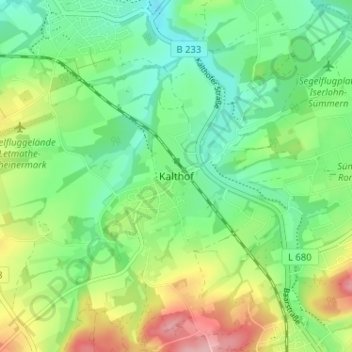
Name: Kalthof topographic map, elevation, terrain.
Average elevation: 170 m
Minimum elevation: 120 m
Maximum elevation: 263 m
Make a donation
Gear up for your next adventure:
As an Amazon Associate, this site earns from qualifying purchases at no extra cost to you.
Other topographic maps
Click on a map to view its topography, its elevation and its terrain.
58640
Deutschland > Nordrhein-Westfalen > Märkischer Kreis > Iserlohn > Kalthof
Average elevation: 168 m
Make a donation
Gear up for your next adventure:
As an Amazon Associate, this site earns from qualifying purchases at no extra cost to you.