
Make a donation
Gear up for your next adventure:
As an Amazon Associate, this site earns from qualifying purchases at no extra cost to you.
Vliet topographic map
Click on the map to display elevation.
Make a donation
Gear up for your next adventure:
As an Amazon Associate, this site earns from qualifying purchases at no extra cost to you.
About this map
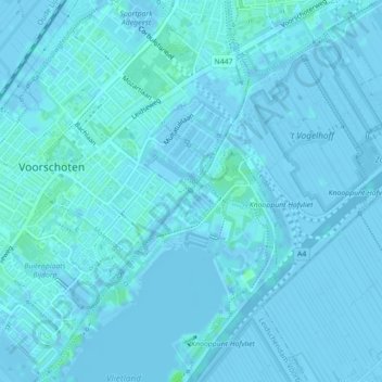
Name: Vliet topographic map, elevation, terrain.
Average elevation: 1 m
Minimum elevation: -4 m
Maximum elevation: 6 m
Make a donation
Gear up for your next adventure:
As an Amazon Associate, this site earns from qualifying purchases at no extra cost to you.
Other topographic maps
Click on a map to view its topography, its elevation and its terrain.
Wilsveen
Nederland > Zuid-Holland > Leidschendam
Wilsveen wordt omgeven door drie polders: Potteveen ten noordwesten van de weg; de Grote Drooggemaakte Polder ten noordoosten van Wilsveen, en de Nieuwe Driemanspolder ten zuiden van de weg. Op de grens van de twee eerstgenoemde polders ligt langs de zogenaamde Molenvaart een molendriegang. Deze drie molens…
Average elevation: -3 m