Geolocate

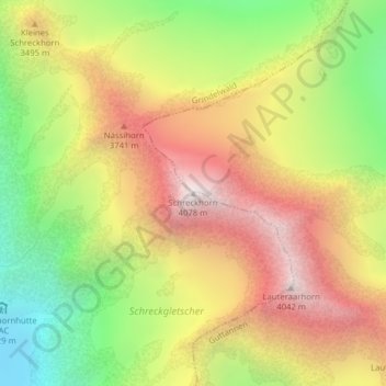
Schreckhorn topographic map

Click on the map to display elevation.

Schreckhorn

Le Schreckhorn, culminant à 4 078 m d'altitude, est le sommet de plus de 4 000 mètres d'altitude le plus septentrional des Alpes bernoises. Il est considéré par les alpinistes comme l'un des plus difficiles à gravir des Alpes bernoises, voire des Alpes suisses.

Wikipedia (CC-BY-SA 3.0)

About this map

Name: Schreckhorn topographic map, elevation, terrain.

Location: Schreckhorn, Grindelwald, Arrondissement administratif d'Interlaken-Oberhasli, Région administrative de l'Oberland, Berne, 3818, Suisse (46.58983 8.11814 46.58993 8.11824)

Average elevation: 3,271 m

Minimum elevation: 2,447 m

Maximum elevation: 4,069 m

Gear up for your next adventure:

Backpacking Tent - Lightweight tent for long-distance hiking trips
🔦LED Flashlight - Powerful and long-lasting flashlight for camping and emergencies
🥾Durable Hiking Shoes - Long-lasting shoes for frequent hiking
🥾Hiking Shoes - Durable and comfortable shoes for trail hiking
🧥Waterproof Hiking Jacket - Protect yourself from rain and wind while hiking

As an Amazon Associate, this site earns from qualifying purchases at no extra cost to you.