
Make a donation
Gear up for your next adventure:
As an Amazon Associate, this site earns from qualifying purchases at no extra cost to you.
Achira topographic map
Click on the map to display elevation.
Make a donation
Gear up for your next adventure:
As an Amazon Associate, this site earns from qualifying purchases at no extra cost to you.
About this map
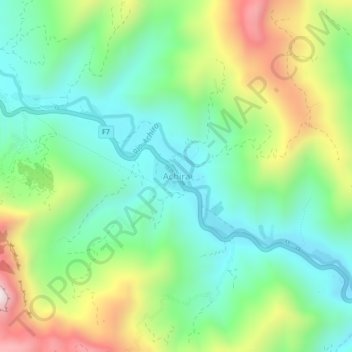
Name: Achira topographic map, elevation, terrain.
Average elevation: 1,541 m
Minimum elevation: 1,284 m
Maximum elevation: 2,049 m
Make a donation
Gear up for your next adventure:
As an Amazon Associate, this site earns from qualifying purchases at no extra cost to you.
Other topographic maps
Click on a map to view its topography, its elevation and its terrain.
Samaipata
Bolivia > Santa Cruz > Provincia Florida > Municipio Samaipata
Se encuentra ubicada en las primeras estribaciones andinas, a 1.670 metros de altitud sobre el nivel del mar. El clima es templado húmedo en la parte noreste, frío y seco al sudoeste con una temperatura promedio anual de 20.5 °C. La topografía varía entre montañas, colinas y valles. Los principales…
Average elevation: 1,695 m