
Make a donation
Gear up for your next adventure:
As an Amazon Associate, this site earns from qualifying purchases at no extra cost to you.
Dahlhaus topographic map
Click on the map to display elevation.
Make a donation
Gear up for your next adventure:
As an Amazon Associate, this site earns from qualifying purchases at no extra cost to you.
Dahlhaus
Dahlhaus ist der nördlichste Stadtteil Lohmars. Umliegende Ortschaften und Weiler sind Boddert im Nordwesten, Halfensbüchel, Schneppensiefen und Brambach im Nordosten, Kombach und Bombach im Südosten, Breideneichen, Stöcken, Hoven und Durbusch im Süden bis Südwesten und Breide im Westen. Dahlhaus befindet sich auf dem Höhenrücken zwischen Agger und Sülz und ist mit 235,4 m der höchstgelegene Stadtteil Lohmars. Der Stadtteil liegt im sog. 3-Städte-Eck, da es jeweils an die Nachbarstädte Rösrath und Overath (beide Rheinisch - Bergischer - Kreis) angrenzt.
Make a donation
Gear up for your next adventure:
As an Amazon Associate, this site earns from qualifying purchases at no extra cost to you.
About this map
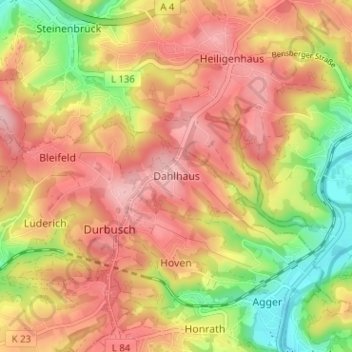
Name: Dahlhaus topographic map, elevation, terrain.
Average elevation: 173 m
Minimum elevation: 78 m
Maximum elevation: 240 m
Make a donation
Gear up for your next adventure:
As an Amazon Associate, this site earns from qualifying purchases at no extra cost to you.
Other topographic maps
Click on a map to view its topography, its elevation and its terrain.