Geolocate

Lac Châteauvert topographic map

Click on the map to display elevation.

About this map

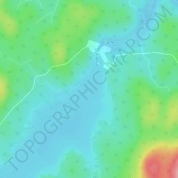
Name: Lac Châteauvert topographic map, elevation, terrain.

Location: Lac Châteauvert, La Tuque, Urban agglomeration of La Tuque, Mauricie, Quebec, Canada (47.75186 -73.89867 47.75196 -73.89857)

Average elevation: 385 m

Minimum elevation: 357 m

Maximum elevation: 482 m

Other topographic maps

Click on a map to view its topography, its elevation and its terrain.

Gear up for your next adventure:

🦟Insect Repellent - Keep mosquitoes and black flies away in wooded areas
Camping Groundsheet - Protect your tent from moisture and dirt
🛏️Sleeping Bag - Warm and compact sleeping bags for outdoor camping
👖Convertible Hiking Pants - Zip-off legs to adapt to changing weather conditions
💡Compact LED Flashlight - Powerful and portable flashlight for outdoor use

As an Amazon Associate, this site earns from qualifying purchases at no extra cost to you.