
Genil topographic map
Click on the map to display elevation.
About this map
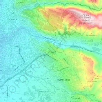
Name: Genil topographic map, elevation, terrain.
Average elevation: 760 m
Minimum elevation: 659 m
Maximum elevation: 1,016 m
Other topographic maps
Click on a map to view its topography, its elevation and its terrain.
Mirador de San Miguel Alto
España > Andalucía > Comarca de la Vega de Granada > Granada
Average elevation: 802 m
Mirador de la Placeta de los Carvajales
España > Andalucía > Comarca de la Vega de Granada > Granada
Average elevation: 743 m
Dehesa del Generalife
España > Andalucía > Comarca de la Vega de Granada > Granada
Average elevation: 846 m
Mirador de San Nicolás
España > Andalucía > Comarca de la Vega de Granada > Granada
Average elevation: 760 m
Lancha del Genil
España > Andalucía > Comarca de la Vega de Granada > Granada
Average elevation: 824 m