
Make a donation
Gear up for your next adventure:
As an Amazon Associate, this site earns from qualifying purchases at no extra cost to you.
Chancay topographic map
Click on the map to display elevation.
Make a donation
Gear up for your next adventure:
As an Amazon Associate, this site earns from qualifying purchases at no extra cost to you.
Chancay
Chancay es una ciudad y puerto peruano, capital del distrito de Chancay, ubicado en la provincia de Huaral en el departamento de Lima. Se encuentra a 78 km al Norte de la ciudad de Lima y está conectada por la carretera Panamericana Norte. Está a una altitud de 43 m s. n. m. Tenía 63 378 hab. en 2015.
Make a donation
Gear up for your next adventure:
As an Amazon Associate, this site earns from qualifying purchases at no extra cost to you.
About this map
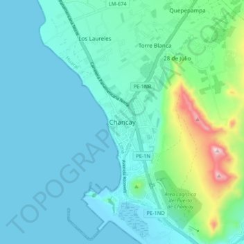
Name: Chancay topographic map, elevation, terrain.
Location: Chancay, Huaral, Lima, Perú (-11.60277 -77.31000 -11.52277 -77.23000)
Average elevation: 74 m
Minimum elevation: 0 m
Maximum elevation: 456 m
Make a donation
Gear up for your next adventure:
As an Amazon Associate, this site earns from qualifying purchases at no extra cost to you.