Geolocate

Mauck topographic map

Click on the map to display elevation.

About this map

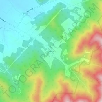
Name: Mauck topographic map, elevation, terrain.

Location: Mauck, Page County, Virginia, United States (38.54040 -78.46640 38.58040 -78.42640)

Average elevation: 468 m

Minimum elevation: 296 m

Maximum elevation: 804 m

Other topographic maps

Click on a map to view its topography, its elevation and its terrain.

Stanley

United States > Virginia > Page County

Average elevation: 328 m

Gear up for your next adventure:

🧤Insulated Winter Gloves - Heavy-duty protection for sub-zero Canadian adventures
🎒Fully Waterproof Backpack - Total protection for photography gear and electronics
🧣Evaporative Cooling Towel - Beat the heat during intense summer climbs
👖Convertible Hiking Pants - Zip-off legs to adapt to changing weather conditions
💡Portable Camping Lamp - Rechargeable lamp for campsite lighting

As an Amazon Associate, this site earns from qualifying purchases at no extra cost to you.