Geolocate

Barile topographic map

Click on the map to display elevation.

About this map

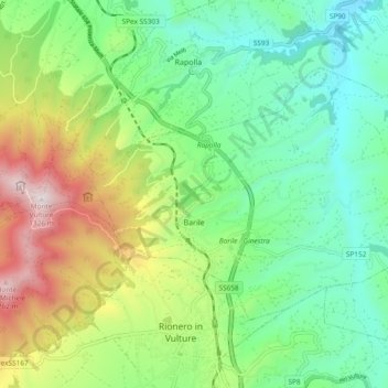
Name: Barile topographic map, elevation, terrain.

Location: Barile, Potenza, Basilicata, 85022, Italy (40.92841 15.64807 40.97464 15.74198)

Average elevation: 598 m

Minimum elevation: 255 m

Maximum elevation: 1,300 m

Other topographic maps

Click on a map to view its topography, its elevation and its terrain.

Viadotto Pantanelle

Italy > Basilicata > Potenza > Nemoli

Average elevation: 1,685 m

Gear up for your next adventure:

🥘Camping Cookware Set - Compact nesting pots and pans for trail cooking
🥾Hiking Boots - Sturdy boots providing ankle support and traction on rugged trails
🧊Insulated Water Bottle - Keeps drinks cold in summer and prevents freezing in winter
🧳Compression Sacks - Maximize space in your backpack by shrinking gear
🔥Emergency Fire Starter - Reliable ignition source for all weather conditions

As an Amazon Associate, this site earns from qualifying purchases at no extra cost to you.