
Make a donation
Gear up for your next adventure:
As an Amazon Associate, this site earns from qualifying purchases at no extra cost to you.
Khorramabad County topographic map
Click on the map to display elevation.
Make a donation
Gear up for your next adventure:
As an Amazon Associate, this site earns from qualifying purchases at no extra cost to you.
About this map
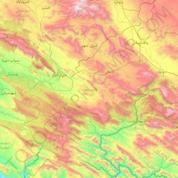
Name: Khorramabad County topographic map, elevation, terrain.
Location: Khorramabad County, Lorestan Province, Iran (32.89116 48.04861 33.90420 48.99893)
Average elevation: 1,702 m
Minimum elevation: 547 m
Maximum elevation: 3,558 m
Make a donation
Gear up for your next adventure:
As an Amazon Associate, this site earns from qualifying purchases at no extra cost to you.
Other topographic maps
Click on a map to view its topography, its elevation and its terrain.
Deh Now-e Karam Ali
Iran > Lorestan Province > Delfan County > دهستان خاوه شمالی
Average elevation: 1,836 m
Make a donation
Gear up for your next adventure:
As an Amazon Associate, this site earns from qualifying purchases at no extra cost to you.
Biatan-e Olya
Iran > Lorestan Province > Borujerd County > Oshtorinan Rural District
Average elevation: 2,146 m
Make a donation
Gear up for your next adventure:
As an Amazon Associate, this site earns from qualifying purchases at no extra cost to you.
ایستگاه تنگ هفت
Iran > Lorestan Province > Khorramabad County > دهستان تنگ هفت
Average elevation: 1,022 m
Make a donation
Gear up for your next adventure:
As an Amazon Associate, this site earns from qualifying purchases at no extra cost to you.
Aleshtar
Iran > Lorestan Province > Selseleh County > Qaleh-ye Mozaffari > Aleshtar
Average elevation: 1,651 m
Make a donation
Gear up for your next adventure:
As an Amazon Associate, this site earns from qualifying purchases at no extra cost to you.