
Isolabona topographic map
Click on the map to display elevation.
About this map
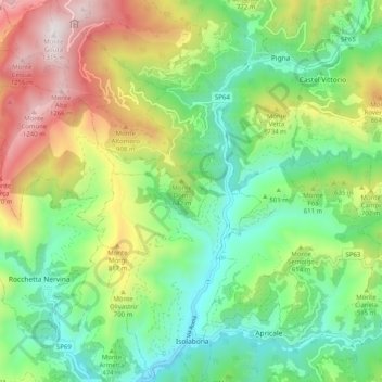
Name: Isolabona topographic map, elevation, terrain.
Location: Isolabona, Imperia, Liguria, Italy (43.87104 7.58845 43.94363 7.67290)
Average elevation: 516 m
Minimum elevation: 81 m
Maximum elevation: 1,304 m
Other topographic maps
Click on a map to view its topography, its elevation and its terrain.
I Palanchi
Italy > Liguria > Imperia > Ventimiglia > Torri Inferiore > Torri Superiore
Average elevation: 305 m