Geolocate

Limonetto topographic map

Click on the map to display elevation.

About this map

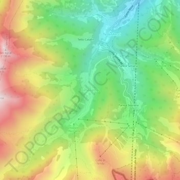
Name: Limonetto topographic map, elevation, terrain.

Location: Limonetto, Limone Piemonte, Cuneo, Piedmont, 12015, Italy (44.15326 7.53714 44.19326 7.57714)

Average elevation: 1,510 m

Minimum elevation: 1,033 m

Maximum elevation: 2,143 m

Gear up for your next adventure:

🥾Trail Hiking Boots - Supportive boots for rough trails
🧭GPS Handheld Device - Reliable GPS navigation for outdoor adventures
🛌Insulated Sleeping Pad - Critical thermal barrier between you and the cold ground
🥾Approach Shoes - Shoes designed for climbing approaches and rugged trails
🧥Softshell Jacket - Windproof and breathable jacket for hiking

As an Amazon Associate, this site earns from qualifying purchases at no extra cost to you.