Geolocate

Eden topographic map

Click on the map to display elevation.

About this map

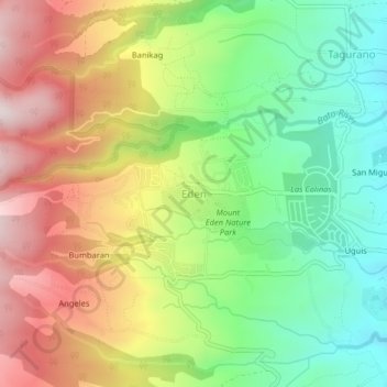
Name: Eden topographic map, elevation, terrain.

Location: Eden, Davao City, Toril District, Davao Region, Philippines (7.01189 125.37781 7.05189 125.41781)

Average elevation: 817 m

Minimum elevation: 527 m

Maximum elevation: 1,179 m

Other topographic maps

Click on a map to view its topography, its elevation and its terrain.

Tamayong

Philippines > Davao City

Average elevation: 778 m

Matina River

Philippines > Davao City > Matina Pangi

Average elevation: 62 m

Baguio District

Philippines > Davao City

Average elevation: 563 m

75-A Matina Aplaya

Philippines > Davao City

Average elevation: 3 m

26-C Silangan

Philippines > Davao City

Average elevation: 4 m

Matina Pangi

Philippines > Davao City

Average elevation: 53 m

Lipadas River

Philippines > Davao City

Average elevation: 1,351 m

Ogdoy River

Philippines > Davao City

Average elevation: 132 m

Mapula River

Philippines > Davao City

Average elevation: 447 m

Ma-a

Philippines > Davao City

Average elevation: 36 m

Wilfredo Aquino

Philippines > Davao City

Average elevation: 10 m

Maa Creek

Philippines > Davao City

Average elevation: 40 m

Gear up for your next adventure:

🧣Merino Neck Gaiter - Protects against wind, sun, and cold at high altitudes
🪑Insulated Seat Pad - Protect your seat from cold rocks and wet logs
Camping Groundsheet - Protect your tent from moisture and dirt
🥾Hiking Gaiters - Protect legs and shoes from mud, snow, and debris
🚲Heavy Duty Bike Lock - Secure your bike at the trailhead or during stops

As an Amazon Associate, this site earns from qualifying purchases at no extra cost to you.