
Wildeck topographic map
Click on the map to display elevation.
About this map
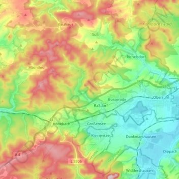
Name: Wildeck topographic map, elevation, terrain.
Location: Wildeck, Landkreis Hersfeld-Rotenburg, Hesse, 36208, Germany (50.91509 9.89623 50.99653 10.06485)
Average elevation: 330 m
Minimum elevation: 208 m
Maximum elevation: 508 m
Other topographic maps
Click on a map to view its topography, its elevation and its terrain.
Bad Hersfeld
Germany > Hesse > Landkreis Hersfeld-Rotenburg
The Flugplatz Johannesberg has the status of Special Airfield. The runway, some 671 m long and 18 m wide, is paved with asphalt and oriented in a north–south direction. The airfield lies on the Johannesberg in the like-named outlying centre at an elevation of 284 m above sea level.
Average elevation: 281 m