Geolocate

Kinkheda topographic map

Click on the map to display elevation.

About this map

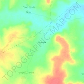
Name: Kinkheda topographic map, elevation, terrain.

Location: Kinkheda, Mantha, Jalna, Maharashtra, India (19.74967 76.43184 19.78967 76.47184)

Average elevation: 511 m

Minimum elevation: 484 m

Maximum elevation: 545 m

Other topographic maps

Click on a map to view its topography, its elevation and its terrain.

Mantha

India > Maharashtra > Mantha

Average elevation: 488 m

Gear up for your next adventure:

🍽️Titanium Camping Spork - Ultralight and indestructible eating utensil
🥾Light Trekking Boots - Supportive boots for multi-day treks
🚲MTB Frame Bag - Carry tools and maps directly on your bicycle frame
🧰Survival Kit - Essential gear for emergencies in the wilderness
🕶️Polarized Sunglasses - Protect your eyes with durable polarized lenses

As an Amazon Associate, this site earns from qualifying purchases at no extra cost to you.