
Make a donation
Gear up for your next adventure:
As an Amazon Associate, this site earns from qualifying purchases at no extra cost to you.
Fischbach topographic map
Click on the map to display elevation.
Make a donation
Gear up for your next adventure:
As an Amazon Associate, this site earns from qualifying purchases at no extra cost to you.
Fischbach
Bann | Bruchmühlbach-Miesau | Enkenbach-Alsenborn | Erzenhausen | Eulenbis | Fischbach | Frankelbach | Frankenstein | Gerhardsbrunn | Hauptstuhl | Heiligenmoschel | Hirschhorn/Pfalz | Hochspeyer | Hütschenhausen | Katzweiler | Kindsbach | Kollweiler | Kottweiler-Schwanden | Krickenbach | Lambsborn | Landstuhl | Langwieden | Linden | Mackenbach | Martinshöhe | Mehlbach | Mehlingen | Mittelbrunn | Neuhemsbach | Niederkirchen | Niedermohr | Oberarnbach | Olsbrücken | Otterbach | Otterberg | Queidersbach | Ramstein-Miesenbach | Reichenbach-Steegen | Rodenbach | Schallodenbach | Schneckenhausen | Schopp | Schwedelbach | Sembach | Steinwenden | Stelzenberg | Sulzbachtal | Trippstadt | Waldleiningen | Weilerbach
Make a donation
Gear up for your next adventure:
As an Amazon Associate, this site earns from qualifying purchases at no extra cost to you.
About this map
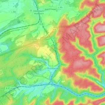
Name: Fischbach topographic map, elevation, terrain.
Average elevation: 332 m
Minimum elevation: 253 m
Maximum elevation: 436 m
Make a donation
Gear up for your next adventure:
As an Amazon Associate, this site earns from qualifying purchases at no extra cost to you.
Other topographic maps
Click on a map to view its topography, its elevation and its terrain.
Schweinstal
Deutschland > Rheinland-Pfalz > Landkreis Kaiserslautern > Krickenbach
Average elevation: 349 m
Althütterhof
Deutschland > Rheinland-Pfalz > Landkreis Kaiserslautern > Otterberg
Average elevation: 307 m
Stüterhof
Deutschland > Rheinland-Pfalz > Landkreis Kaiserslautern > Waldleiningen
Average elevation: 428 m
Kreuzberg
Deutschland > Rheinland-Pfalz > Landkreis Kaiserslautern > Oberarnbach
Average elevation: 399 m
Make a donation
Gear up for your next adventure:
As an Amazon Associate, this site earns from qualifying purchases at no extra cost to you.
Lauerhof
Deutschland > Rheinland-Pfalz > Landkreis Kaiserslautern > Otterberg
Average elevation: 296 m
Weinbrunnerhof
Deutschland > Rheinland-Pfalz > Landkreis Kaiserslautern > Otterberg > Weinbrunnerhof
Average elevation: 319 m
Hirschhorner Bordenmühle
Deutschland > Rheinland-Pfalz > Landkreis Kaiserslautern > Sulzbachtal > Hirschhorner Bordenmühle
Average elevation: 262 m
Make a donation
Gear up for your next adventure:
As an Amazon Associate, this site earns from qualifying purchases at no extra cost to you.
Kaulbach
Deutschland > Rheinland-Pfalz > Landkreis Kaiserslautern > Reichenbach-Steegen
Average elevation: 328 m