
Make a donation
Gear up for your next adventure:
As an Amazon Associate, this site earns from qualifying purchases at no extra cost to you.
Mount Ayanganna topographic map
Click on the map to display elevation.
Make a donation
Gear up for your next adventure:
As an Amazon Associate, this site earns from qualifying purchases at no extra cost to you.
Mount Ayanganna
The slopes of Mount Ayanganna are covered in tall-canopy lower montane forest, up to about 1100 metres. Above this elevation, there is a series of "steps" - relatively flat plateaus separated by steeper slopes. The poorly drained plateaus support low-canopy forest or terrestrial bromeliads. The slopes support medium-canopy high-montane forest. The amphibians and reptiles of Ayanganna have been surveyed.
Make a donation
Gear up for your next adventure:
As an Amazon Associate, this site earns from qualifying purchases at no extra cost to you.
About this map
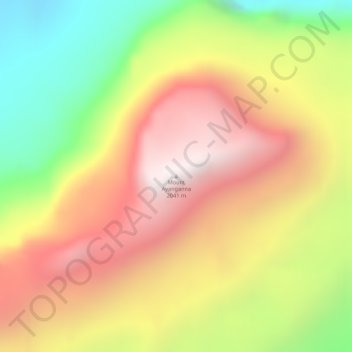
Name: Mount Ayanganna topographic map, elevation, terrain.
Average elevation: 1,573 m
Minimum elevation: 981 m
Maximum elevation: 2,042 m
Make a donation
Gear up for your next adventure:
As an Amazon Associate, this site earns from qualifying purchases at no extra cost to you.