Geolocate

Viewpoint topographic map

Click on the map to display elevation.

About this map

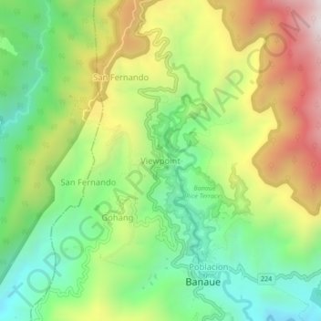
Name: Viewpoint topographic map, elevation, terrain.

Location: Viewpoint, Banaue, Ifugao, 3601, Philippines (16.90693 121.03584 16.94693 121.07584)

Average elevation: 1,307 m

Minimum elevation: 904 m

Maximum elevation: 1,895 m

Other topographic maps

Click on a map to view its topography, its elevation and its terrain.

Banaue Rice Terraces

Philippines > Ifugao > Banaue > Viewpoint > Pan-ngat

Average elevation: 1,313 m

Batad Rice Terraces

Philippines > Ifugao > Banaue > Batad

Average elevation: 1,003 m

Banaue Rice Terraces

Philippines > Ifugao > Banaue > Viewpoint > Pan-ngat

Average elevation: 1,313 m

Banaue Rice Terraces

Philippines > Ifugao > Banaue > Poblacion

Average elevation: 1,313 m

Banaue Rice Terraces

Philippines > Ifugao > Banaue > Viewpoint > Pan-ngat

Average elevation: 1,313 m

Gear up for your next adventure:

🚲MTB Frame Bag - Carry tools and maps directly on your bicycle frame
💧Hydration Pack - Hands-free hydration system for long hikes
🧰Emergency Multi-Tool - Compact multi-tool for outdoor survival
🧢Outdoor Cap - Protective cap for sun and rain during hikes
💧Collapsible Water Bottle - Space-saving water bottle for outdoor activities

As an Amazon Associate, this site earns from qualifying purchases at no extra cost to you.