
Make a donation
Gear up for your next adventure:
As an Amazon Associate, this site earns from qualifying purchases at no extra cost to you.
Willingen (Upland) topographic map
Click on the map to display elevation.
Make a donation
Gear up for your next adventure:
As an Amazon Associate, this site earns from qualifying purchases at no extra cost to you.
Willingen (Upland)
Die Hoppecke fließt nach Norden ab, erreicht nach kurzem Lauf den westlichen Ortsrand von Willingen. Weiter nach Norden fließend verlässt sie wenig später das Gemeindegebiet Richtung Brilon-Wald. Nordwestlich der Hoppecke bildet der Höhenzug zwischen Langenberg und Hoppernkopf (805 m) die Grenze zu Olsberg und Brilon. Der Hoppernkopf leitet nach Norden zum Höhenzug Schellhorn (max. 761 m) über, der in Nordrhein-Westfalen im Stadtgebiet von Brilon liegt.
Make a donation
Gear up for your next adventure:
As an Amazon Associate, this site earns from qualifying purchases at no extra cost to you.
About this map
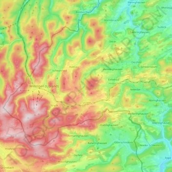
Name: Willingen (Upland) topographic map, elevation, terrain.
Average elevation: 567 m
Minimum elevation: 355 m
Maximum elevation: 844 m
Make a donation
Gear up for your next adventure:
As an Amazon Associate, this site earns from qualifying purchases at no extra cost to you.
Other topographic maps
Click on a map to view its topography, its elevation and its terrain.
Burg Hessenstein
Deutschland > Hessen > Landkreis Waldeck-Frankenberg > Ederbringhausen
Die Höhenburg befindet sich in einsamer Waldlage etwa 1,7 km südöstlich von Ederbringhausen auf einem etwa 327 m hohen, südlichen Bergsporn des Kesebergs (431,2 m), auf dessen nördlichem Ausläufer die Ruine Keseburg liegt. Südlich umfließt der Lengelbach Berg und Burg und mündet etwa 500 m westlich…
Average elevation: 348 m
Make a donation
Gear up for your next adventure:
As an Amazon Associate, this site earns from qualifying purchases at no extra cost to you.