
Make a donation
Gear up for your next adventure:
As an Amazon Associate, this site earns from qualifying purchases at no extra cost to you.
St. Walpurgis topographic map
Click on the map to display elevation.
Make a donation
Gear up for your next adventure:
As an Amazon Associate, this site earns from qualifying purchases at no extra cost to you.
St. Walpurgis
St. Walpurgis ist eine Wallfahrtskapelle, die zur Gemeinde Kirchehrenbach im oberfränkischen Landkreis Forchheim gehört, und zugleich einer von zwei amtlich benannten Gemeindeteilen. St. Walpurgis liegt etwa eineinhalb Kilometer südsüdöstlich des Ortszentrums von Kirchehrenbach auf einer Höhe von 507 m ü. NHN. im äußersten Südwesten der Wiesentalb.
Make a donation
Gear up for your next adventure:
As an Amazon Associate, this site earns from qualifying purchases at no extra cost to you.
About this map
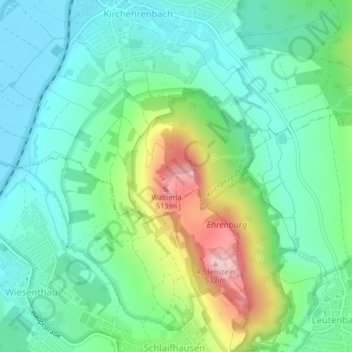
Name: St. Walpurgis topographic map, elevation, terrain.
Average elevation: 347 m
Minimum elevation: 274 m
Maximum elevation: 528 m
Make a donation
Gear up for your next adventure:
As an Amazon Associate, this site earns from qualifying purchases at no extra cost to you.