
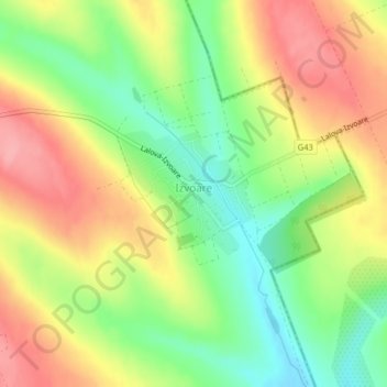
Izvoare topographic map
Interactive map
Click on the map to display elevation.
About this map
Name: Izvoare topographic map, elevation, terrain.
Location: Izvoare, Orhei District, Moldova (47.54674 28.94888 47.55547 28.96261)
Average elevation: 200 m
Minimum elevation: 146 m
Maximum elevation: 254 m
Other topographic maps
Click on a map to view its topography, its elevation and its terrain.
Dubăsari town council
Dubăsari town council, Dubasari District (Transnistria), Administrative-Territorial Units from the Left Bank of the Dniester, Transnistria, Moldova
Average elevation: 90 m
посёлок Геологов
Moldova > Transnistria > Dubăsari town council
посёлок Геологов, Dubăsari town council, Dubossary District, Administrative-Territorial Units from the Left Bank of the Dniester, Transnistria, 4520, Moldova
Average elevation: 31 m