
Thank you for supporting this site ❤️
Make a donation
Make a donation
Gear up for your next adventure:
As an Amazon Associate, this site earns from qualifying purchases at no extra cost to you.
Siculiana topographic map
Click on the map to display elevation.
Thank you for supporting this site ❤️
Make a donation
Make a donation
Gear up for your next adventure:
As an Amazon Associate, this site earns from qualifying purchases at no extra cost to you.
About this map
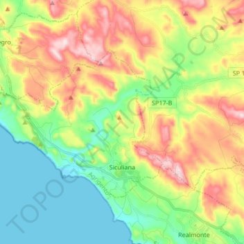
Name: Siculiana topographic map, elevation, terrain.
Location: Siculiana, Agrigent, Sizilien, 92010, Italien (37.32366 13.30911 37.39189 13.44369)
Average elevation: 165 m
Minimum elevation: 0 m
Maximum elevation: 425 m
Thank you for supporting this site ❤️
Make a donation
Make a donation
Gear up for your next adventure:
As an Amazon Associate, this site earns from qualifying purchases at no extra cost to you.
Other topographic maps
Click on a map to view its topography, its elevation and its terrain.
Capreria
Italien > Sizilien > Agrigent > Palma di Montechiaro > Marina di Palma
Average elevation: 70 m