
Make a donation
Gear up for your next adventure:
As an Amazon Associate, this site earns from qualifying purchases at no extra cost to you.
Prunières topographic map
Click on the map to display elevation.
Make a donation
Gear up for your next adventure:
As an Amazon Associate, this site earns from qualifying purchases at no extra cost to you.
About this map
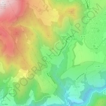
Name: Prunières topographic map, elevation, terrain.
Average elevation: 966 m
Minimum elevation: 498 m
Maximum elevation: 1,610 m
Make a donation
Gear up for your next adventure:
As an Amazon Associate, this site earns from qualifying purchases at no extra cost to you.
Other topographic maps
Click on a map to view its topography, its elevation and its terrain.
Brévardière
Frankrijk > Auvergne-Rhône-Alpes > Isère > Saint-Pierre-de-Chartreuse
Average elevation: 1,183 m
Make a donation
Gear up for your next adventure:
As an Amazon Associate, this site earns from qualifying purchases at no extra cost to you.
Petit Som
Frankrijk > Auvergne-Rhône-Alpes > Isère > Saint-Christophe-sur-Guiers
Average elevation: 1,467 m
Make a donation
Gear up for your next adventure:
As an Amazon Associate, this site earns from qualifying purchases at no extra cost to you.
Montalieu
Frankrijk > Auvergne-Rhône-Alpes > Isère > Saint-Vincent-de-Mercuze
Average elevation: 523 m
Pointe Ouest de Jasse Bralard
Frankrijk > Auvergne-Rhône-Alpes > Isère > Livet-et-Gavet
Average elevation: 2,097 m
Make a donation
Gear up for your next adventure:
As an Amazon Associate, this site earns from qualifying purchases at no extra cost to you.
Make a donation
Gear up for your next adventure:
As an Amazon Associate, this site earns from qualifying purchases at no extra cost to you.
Bourg Menu
Frankrijk > Auvergne-Rhône-Alpes > Isère > Saint-Andéol > Bourg Menu
Average elevation: 1,237 m
Uriage Les Bains
Frankrijk > Auvergne-Rhône-Alpes > Isère > Saint-Martin-d'Uriage > Uriage Les Bains
Average elevation: 618 m
Make a donation
Gear up for your next adventure:
As an Amazon Associate, this site earns from qualifying purchases at no extra cost to you.
Make a donation
Gear up for your next adventure:
As an Amazon Associate, this site earns from qualifying purchases at no extra cost to you.